Experience with the Final Project
See Full Report: GEOB 270 - Final Project Report
Project Summary:
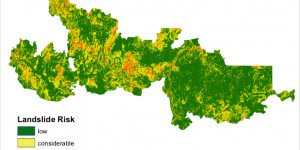
In British Columbia, wildfires pose a significant threat to natural ecosystems as well as human infrastructure. My colleague and I decided to not only look at historical wildfire trends but to use this information to inform our risk assessment for one wildfire in 2017. The 2017 Plateau Complex was the largest fire in BC history, and it meant significant and long-term changes to burned areas and the surrounding environment. Looking at potential landslide risk using slope topography and burn severity data, we were able to determine areas of ‘extreme’ risk. These areas were then crossed referenced with at-risk fish habitat. The final result was a map of the Plateau Complex Fire highlighting areas that were ‘at risk’ of detrimental effects to surrounding fish habitat due to landslides.
Project Management:
This report was organized in three stages:
- Preliminary Research: We took a considerable amount of time to research the risks associated with wildfires in BC, looking particularly at precipitation induced landslides. Critically looking through multiple sources, we narrowed our analysis down to focus only on those decerning critical fish habitat.
- Analysis: This was the bulk of our report. This stage involved acquiring and editing/filtering data collected from open sources, performing an analysis using ARC-GIS, synthesizing maps and visually representing our data.
- Interaction: Our final step in the report was to summarize our findings, and provide a discussion based on our analysis. This involved critically evaluating our analysis and discussing uncertainty and error, as well as further research opportunities.
General Learning Significance:
This project integrated relevant societal issues with GIS theory and practical GIS techniques using ESRI ARC-MAP software. Having the freedom to chose our own methods in data visualization and representation, my colleague and I were able to explore the software through our own understanding and create a report that was entirely our own. Furthermore, having issues presented with no clear solution, we discovered certain ARC-MAP tools such as ‘raster calculator’, and raster-vector conversion that not only allowed us to achieve our goals but forced us to engage with the software and forge a deeper understanding GIS analysis techniques. Overall, we gained insight into the real-world consequences of wildfires in BC, and we hope that our research can be seen as a practical tool that aids in our goal of assessing the future of forest ecosystems.
Learning Significance