
Rewilding the Elwha River: A Success Story in Ecological Restoration
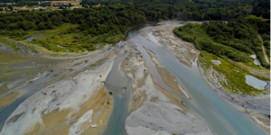
APBI 423 - Term Paper: The goal of this assignment was to write a short and engaging summary article on an interesting ecological restoration project. I chose to investigate the impacts of large-scale dam removal for the Elwha River Restoration Project, WA, USA.
Public Perceptions and Priorities on Human-Coyote Conflict in Vancouver, BC
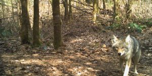
APBI 495 - Term Project For my final project in this course, my colleagues and I had the opportunity to work with the Stanley Park Ecology Society Coexisting with Coyotes Program. We created a survey to gauge public perceptions and priorities on urban coyotes in the Greater Vancouver Regional District, with the goal of obtaining recent public opinion data that can be used to inform program directives as well as urban wildlife conservation management strategies.
The Effects of Prescribed Burning on Vegetation Community Composition: A Case Study at Cedar Creek Ecosystem Science Reserve
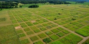
BIOL 406 - Term Project: While fire can be perceived as an unwanted event, it can be used as an ecological service for ecosystems that depend on fire cycles. Oak savannas would be considered one of these ecosystems as they thrive and benefit from burnings. For my final project, my colleagues and I wanted to investigate whether prescribed burning influences biodiversity within the Cedar Creek oak savanna. We performed all our data manipulation and statistical analysis using Rstudio software.
Modelling Avalanche Risk Using ERA-5 Climate Data and Multiple Linear Regression
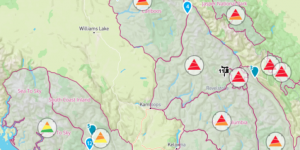
EOSC 410 - Term Project: The capstone assignment for this data science course involved investigating a research question using publicly available data and analyzing this data in Python using the skills we learned throughout the term.
Indigenizing the Human Imagination: How Indigenous Speculative Fiction Acts as a Form of Literary Resistance

FNIS 220 - Term Paper: The goal of this research essay was to explore one of the creative texts discussed in the FNIS 220 class more deeply while providing experience in academic research in the field of Indigenous representation.
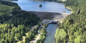
Using the Horton Index to Describe Catchment-Scale Evapotranspiration: A case study of the Umpqua River Catchment, Oregon
ENVR 420 - Lab Assignment: In this project, I used hydrological and land-cover data from a watershed in Oregon, USA, to evaluate how patterns of hydrological partitioning are influencing catchment scale evapotranspiration. Data was collected from the MOPEX dataset online, processed and analyzed in R-Studio.
Comparing Different Methodologies for Quantifying Evapotranspiration: A case study in Southwestern British Columbia
ENVR 420 - Lab Assignment: The purpose of this report was to compare the different methods for measuring daily evapotranspiration in a watershed near Campbell River, BC. Hourly streamflow, groundwater level, evapotranspiration, precipitation, and temperature data were collected and then later processed using R programming software.
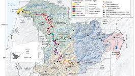
Using ArcGIS to Identify Major Sediment-Contributing Tributaries in the Fraser River Basin, BC
GEOB 448A - Research Project For my directed studies, supervised by Dr. Marwan Hassan (UBC Geography), I was tasked with identifying major tributaries in the Fraser Basin which are contributing sediment to the Fraser River main stem. I used ArcGIS to delineate the Fraser stream network and associated watershed boundaries, then identified tributaries that flow into large water bodies (i.e. lakes, reservoirs) which are acting as sediment sinks.
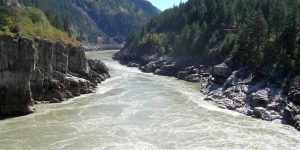
Standard Deviation of Streambed Elevation Profiles as a Method to Quantify Channel Bed Roughness and its Relationship to Channel Stability: A case study for a small mountain creek in Southwestern British Columbia
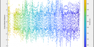
GEOB 406 - Term Project: This course gave me the unique opportunity to do a research project using data collected for an ongoing project in the Department of Geographical Sciences. I was tasked with performing my own analysis and writing a full scientific report on my findings.
Case Study Analysis: The Role of Indigenous Traditional Ecological Knowledge in EIA
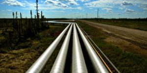
GEOB 309 - Term Paper: This capstone assignment required my colleague and I did a report on a specific topic in EIA. My colleague and I decided to take a critical approach in examining the role of Traditional Ecological Knowledge in the EIA process, as it relates to the Mackenzie Valley Pipeline Project, NWT, Canada.
Relative Annual Mass Balance and its Connection to Surge Events on Lowell Glacier, Yukon, Canada
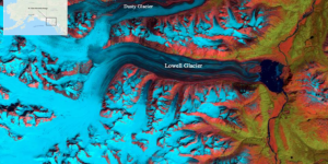
GEOB 408 - Term Project: As my final project for the course, I conducted research on the Lowell Glacier in the Yukon Territory. My goal was to examine the relationship between glacier mass balance and surging events. This involved tracking ELA of the Lowell Glacier over time using LANDSAT imagery in conjunction with elevation data, as well as previously published work using ArcGIS.
Strategies for Classifying Risk & Priority Areas Using ArcGIS: A Qualitative Assessment of the UBC Point Grey Cliffs
GEOB 308 - Term Project: GIS Analysis of erosional hazards on the Point Grey cliffs at UBC using data collected from site surveys and relevant scientific literature.
Classification of Land Cover Types Using Remotely Sensed Imagery
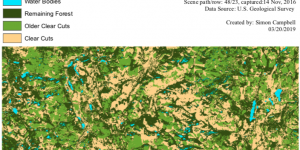
GEOB 373 - Term Project: As my final project for this course, I chose to examine the status of forests affected by logging activities for an area near Baker Creek, BC. This was done using ArcGIS to classify a remotely sensed LANDSAT image and perform an accuracy assessment on my results.
Final Project - Risks Associated with Fire Activity in the Cariboo Region, 2017
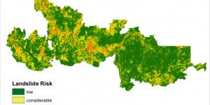
GEOB 270 - Term Project: Under current human and climate pressures, forest fires are becoming more and more severe and difficult to contain. Even after a fire is controlled, changes in forest cover, ground-surface conditions, and hydrologic processes can lead to ongoing risks downslope of the burned area. in our report, we assessed the impact fires can have on landslide risk by looking at the largest fire in the Cariboo fire zone in 2017, as well as the associated potential impacts on fish habitat.
Environmental Impact Assessment of Garibaldi Ski Resort, Squamish BC
GEOB 270 - Lab Assignment: The overall goal of this activity was to gain an understanding of spatial joins and overlays using raster and vector data, in order to create maps of the proposed ski resort at Garibaldi, Squamish that could be used for an environmental impact assessment. These maps were designed to show the project boundary, infrastructures such as roadways, restricted/protected areas, as well as elevation, and slope aspect that together would highlight areas where the proposed ski resort could be built.
Housing Affordability: Working with Census Data
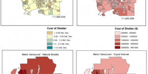
GEOB 270 - Lab Assignment: My task was to visualize and work with housing cost data at different levels of resolution and different time frames and then to explore various methods for classifying quantitative data. This involved compiling maps to show the cost of housing in Metro Vancouver, and how this has changed over the last 5 years, from 2011 to 2016.
Planning for Flooding/Storm Surge
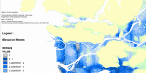
GEOB 270 - Lab Assignment: In this project, I was tasked with creating a series of maps that highlight areas in Metro Vancouver that are at risk of flooding or a storm surge.