EIA Report - Summary of analysis and results, recommendations, and other environmental considerations:
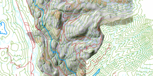
My analysis was an attempt to answer a few questions surrounding the legitimacy and prevalence of the ski resort, and what factors may be limiting/deterrents of the project. It involved looking at the snow line elevation of 555 meters (where on average, an area is high enough for snow to accumulate), and eliminating areas that lie below the snow line. Then I had to look at the areas within the project boundary that are ecologically protected; such as old growth forest, ungulate ranges, and the areas surrounding river networks (river buffer zone). These areas needed to be avoided if a ski resort is to be built. Finally, I looked at nearby to determine whether or not this area is accessible, and if not, how many roadways will have to be paved in order to access the ski resort. Two maps were created, with and without elevation contours, both showing the proposed project boundary, as well as all the above factors represented by area.
Using these maps as a basis for examining the potential adverse effects of the proposed development, it is clear to me that the proposed ski resort will have significant adverse effects, and mitigation efforts to avoid such effects will be extensive and require further research. Within the project boundary, 29.9% of terrain lies below the 555m snowline elevation. This means one-third of the total area for that is eligible for the ski resort will not be getting consistent snow throughout the winter season. With that, 25.3% of the total project boundary lies within ecologically protected areas, where 6.8% is old growth forest, 7.9% is ungulate habitat, and 13.9% is within the river buffer zone. This means that a considerable portion of the proposed project area is not eligible for development. Road access to any areas that lie within eligible terrain (i.e, above 555m and not within ecologically protected areas), is not ideal as it would have to cross over a protected river buffer zone at some point. In fact, I do not see any potential areas that give protected areas adequate space from a ski resort, and there does not seem to be any legitimate location for which a ski resort can be built without interfering with these protected areas. May I also point out that these parameters (snow line elevation in particular) are subject to change due to global temperature increases. There is potential for the proposed ski resort to becoming an area that will not receive any snow accumulation within the next few decades, and this needs to be considered in determining the project location. I would suggest that the proponent either re-evaluate the project boundary location, or further it’s research into mitigation efforts.
Sources of error for this analysis should be disclosed to the map user. It must be stated the analysis relies on accurate data with a certain degree of precision from which I am able to make an informed EIA map. I have relied on the 1:250,000 scale DEM file provided by the Department of Geography at UBC, and I consider it to be accurate. However, there still exists some possible errors in data collection, meaning that although it is from a trusted source, it may not be 100% accurate. Also, the ecologically protected areas have a certain degree of uncertainty, as they have been determined by generalization. For example, the ungulate winter range area may not be exactly what is outlined in the EIA map provided, due to changes in population, habitat disturbances, etc. The map user should be critical of these errors, and take them into consideration when using this map for any further research/decisions regarding the proposed ski resort.
Fig. 1: EIA Map - Elevation Model
Fig. 2: EIA Map - Ecologically Protected Areas
Integrated a public project proposal in the context of EIA, and gained experience in using a technical analysis to facilitate a discussion over broader policy issues relating to project development.