Project Summary Report: GEOB448A_ProjectSummary_SimonCampbell
This research project was inspired by a study by Dr. Marwan Hassan and Dr. Kai Tsuruta, which was focused on developing a large-scale, physically-based, distributed suspended sediment transport model on the Fraser River Basin: https://agupubs.onlinelibrary.wiley.com/doi/full/10.1029/2017JF004578
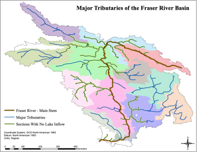
We wanted to see if glaciated basins such as the Fraser, organize in such a way where only the main stem (first-order stream) contributes sediment to the outlet, and if we could identify major tributaries in the Fraser Basin that are not contributing sediment (i.e. disconnected) to the main stem. 14 watersheds were delineated and 24 first-order tributaries were identified using ArcMap 10.6. 20 of these tributaries were found to have no lake inflow, and therefore may be able to contribute sediment to the main stem of the Fraser River.