
Strategies for Classifying Risk & Priority Areas Using ArcGIS: A Qualitative Assessment of the UBC Point Grey Cliffs
GEOB 308 - Term Project:
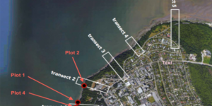
GIS Analysis of erosional hazards on the Point Grey cliffs at UBC using data collected from site surveys and relevant scientific literature.