
Classification of Land Cover Types Using Remotely Sensed Imagery
GEOB 373 - Term Project:
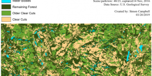
As my final project for this course, I chose to examine the status of forests affected by logging activities for an area near Baker Creek, BC. This was done using ArcGIS to classify a remotely sensed LANDSAT image and perform an accuracy assessment on my results.