
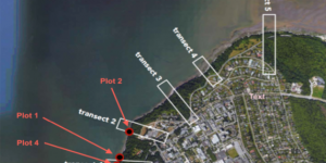
This study undertook a qualitative assessment of slope stability of the Point Grey Cliffs through an evaluation of literature and field site visits. Data was analyzed to produce a map of relative instability risk for our selected sites. Vegetation, D50 and slope angle appeared to be significant components of instability, and areas with low vegetation, high slope angle and certain D50 values were found to underlie high-risk slopes. The figures we created holds important implications for future development considerations in terms of stormwater routing and further land development.
Full Report (PDF) Here: GEOB 308 - Capstone Assignment